
From Hassan Abdal to Kashgar is Called The Karakoram Highway
This 1,300 km long highway is not only the most important trade link between Pakistan and China but also serves as a vital ground route connecting the remote areas of Gilgit-Baltistan with the federal capital and other cities. It provides access to some of the most beautiful mountain and historical sites in the country. Whether it is the Gandhara civilization of Taxila, the Marco Polo sheep of Khunjerab, the ancient inscriptions on the rocks of Chilas, or the stunning landscapes of Hunza and Nagar, this highway is an important source of satisfaction for both tourists and researchers.
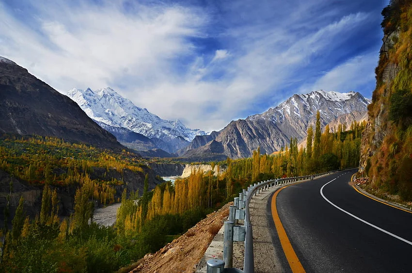
This invaluable example of the hard work and courage of Pakistani and Chinese engineers and laborers is something that cannot fail to astonish anyone who witnesses it. This is why it is regarded as the eighth wonder of the world. Over four hundred workers and engineers lost their lives while constructing this marvel, which was built amidst the world’s greatest and most difficult mountains. Despite extreme weather conditions, heavy snowfall, and the constant threat of landslides, the building and maintenance of this road is truly a miracle, and the role of the experts and workers of the FWO (Frontier Works Organization) in making this possible is highly commendable.
The starting point of this magnificent highway is near Hassan Abdal, just a 45-minute drive from the federal capital, Islamabad. The famous ruins of Taxila are located only 15 minutes away from here. These Buddhist remains, dating back to BC, are considered an important part of the world’s cultural heritage. The visit to these ruins, including Juliyan, Sirkap, and Bhirmound, acquaints one with the rise and fall of human history, civilization, culture, and forgotten stories of architecture. From statues of Buddha and other figures to ordinary household utensils and the remains of buildings, everything offers a comparison between the thoughts, lifestyle, needs, customs, and arts of both the past and present.

The Karakoram Highway begins in the Hazara district. The lush green views and bustling towns of Hazara accompany you until Thakot. After passing through Haripur, Havelian, Abbottabad, and Mansehra, a dreamlike view of a beautiful area emerges. A road from Mansehra leads to Naran and Kaghan, providing access to these scenic valleys. From Thakot, the mighty Indus River meanders alongside the Karakoram Highway, continuing all the way to Gilgit. Crossing the famous long bridge at Thakot, you will see the vast and majestic Indus River, which, on your left, provides water to the world’s largest dam, Tarbela, hidden behind the mountains. As you go further, at many places, the depth between the river and the road increases so much that the great river appears as a mere line far below.
Bisham is an important location on the Karakoram Highway, located half an hour from Thakot. Bisham is in the Swat district and serves as a trade center for Chinese products. From this location, you can access other notable sites in Swat through Shangla. The view of the mountainous region surrounding Bisham along the Indus River presents a captivating landscape.
Further ahead, you will see the people of Kohistan on both sides of the Indus River, going about their daily tasks in traditional attire. The area of Kohistan is also filled with stunning natural beauty, and the wooden houses and shops give a glimpse of the harsh cold experienced here in winter. Due to landslides in many parts of Kohistan, the Karakoram Highway is often damaged, and the road may be blocked, but the FWO workers are quick to repair the road and make it usable. The rivers descending from the distant heights in Kohistan make the journey even more memorable and fascinating.

After Kohistan, Chilas begins. The area of Chilas is composed of dry and barren mountains. In the highlands and within the mountains, there are green pastures with plenty of trees, but the region along the Karakoram Highway near Chilas consists of rugged rocky mountains. Here, one can find various images and shapes engraved on rocks dating back to BC times. These carvings were made by traders, soldiers, and followers of different religions who passed through this historical route. The rock formations, adorned with images of humans and animals, as well as triangular and circular shapes, are a point of interest for many. Chilas is also known as Diamer, named after the towering peak Diamer (commonly known as Nanga Parbat). This peak is of great interest to tourists and is ranked as the ninth highest mountain in the world, but it is considered the most dangerous and difficult peak to climb. The local name of this peak is Diamer, and the entire region is known by this name. A view of this peak can be seen from the Karakoram Highway. The Rai Kot Bridge is a well-known spot on this road, and jeeps to Nanga Parbat and Fairy Meadows are always available from here. In fact, Nanga Parbat plays a vital role in enhancing the fame of the Karakoram Highway.
After Chilas or Diamer, you enter the Gilgit Division. Jaglot is an important location on the Karakoram Highway where one can travel to Astor, Deosai, Baltistan, and Nanga Parbat.
At Jaglot, on the Karakoram Highway, is a point where three of the world’s greatest mountain ranges converge. A white monument has been built at this location to mark the junction of the Karakoram, Himalayas, and Hindu Kush mountain ranges. Standing at this point along the Indus River, you can see all three mountain ranges at the same time. From here, a road known as the Gilgit-Skardu Road branches off and heads towards Baltistan, where countless adventure spots and mountain sites await.
Gilgit, the capital of the Northern Areas, is a beautiful mountain city of great importance due to its tourist, trade, and social significance. The city is only a few kilometers away from the Karakoram Highway, and from here, numerous beautiful regions are within reach. Naltar, Ashkoman, Ghizer, Yasin, Shandur, and many other areas are part of Gilgit, and you can explore them by jeep.
Just a short distance from Gilgit, Nagar begins. Rakaposhi, the distinguishing feature of Nagar, continuously reveals its majestic peak behind the mountains along the Karakoram Highway. Nagar and Hunza lie on opposite sides of the Karakoram Highway, offering abundant waterfalls, glaciers, mountain peaks, and rivers, never letting the attention of tourists wander. Rakaposhi, Dastgil Sar, Kenyan Gush, Altit, Butora, Pasu, and many other peaks, along with the long glaciers of Butora and Pasu, and the rivers of Hunza and Khunjerab, add to the beauty of this highway.
Sost is the part of Hunza that functions as the administrative border between Pakistan and China. Here, there is a large market for goods imported from China, and many importers and exporters are engaged in exchanging goods.

Beyond Sost, the journey to Khunjerab is desolate, comprising difficult mountains and continuous ascents. At Khunjerab, the elevation of the Karakoram Highway reaches 4,800 meters, making it the world’s highest paved international road. The Khunjerab Pass remains covered in snow year-round, and the towering mountains, draped in white, present a stunning sight. Trade and travel on this road continue from May to October, while it is closed during the rest of the year due to heavy snow.
One more feature of Khunjerab is its designation as the Khunjerab National Park, which is home to some of the world’s rarest and endangered wildlife, including Marco Polo sheep, snow leopards, and blue sheep, among others. Other wildlife includes marmots, wolves, brown bears, and more.
